The study of ancient maps and the geography of the Bible is essential for understanding the historical context of biblical narratives. Bible maps provide visual representations of the geographical locations mentioned in the Bible, helping readers to better grasp the significance of these places. There is a wide range of Bible maps available, covering both the Old and New Testaments. These maps often include details such as the journey of Abraham, the Exodus from Egypt, the biblical cities of Jerusalem and Jericho, and the missionary journeys of Paul. Bible maps are valuable tools for scholars and students of the Scriptures, allowing them to explore the ancient world and gain a deeper understanding of biblical events and locations.
Key Takeaways:
- Ancient maps and biblical cartography are essential for understanding the geography of the Bible.
- Bible maps provide visual representations of biblical landforms, landmarks, and ancient cities.
- Studying Bible maps enhances comprehension of biblical narratives and the historical context.
- There are various types of Bible map resources available, including atlases and illustrated maps.
- Exploring ancient maps allows for a deeper understanding of the ancient world and its significance within the biblical context.
The Importance of Bible Maps in Studying the Scriptures
Bible maps play a crucial role in Bible study as they provide visual representations of the geographical locations mentioned in the Scriptures. By studying these maps, readers can gain a deeper understanding of the historical and cultural context in which biblical events took place. The use of maps helps to bring the biblical narrative to life, allowing readers to visualize the landscapes, landforms, and landmarks that are integral to the stories and teachings of the Bible. Additionally, Bible maps help to highlight the distances between locations, the topography of the land, and the borders of ancient nations, providing valuable insights into the journeys and movements of biblical characters.
As I delve into the study of the Scriptures, I find that Bible maps enhance my understanding of the biblical events and the ancient world. By visually exploring the geographical locations mentioned in the Bible, I am able to grasp the context and significance of these places in relation to the biblical narrative. The visual representations provided by the maps allow me to connect the dots between different passages and better comprehend the journeys of biblical characters.
Moreover, the historical context and geographical settings revealed by Bible maps shed light on the cultural and social aspects of biblical events. I am able to gain a deeper appreciation for the challenges faced by biblical figures as they traversed the diverse landscapes and encountered different nations. These maps assist me in visualizing the routes taken by prophets, the exodus of the Israelites, and the travels of apostles, providing a more vivid understanding of the biblical narrative.
In summary, Bible maps are invaluable tools for studying the Scriptures. They enable readers to visually engage with the geographical locations mentioned in the Bible, deepening their comprehension of the historical context and enhancing their overall study experience. By incorporating maps into Bible study, I am able to gain a more comprehensive understanding of the biblical events, visualize the ancient world, and connect with the stories and teachings of the Scriptures on a deeper level.

The Significance of Visual Representations
The visual representations provided by Bible maps offer a unique perspective on the biblical narrative. They allow readers to go beyond mere words and engage with the physical landscapes and locations that played a central role in the lives of biblical figures. By visually connecting with the ancient world through maps, readers can better appreciate the challenges, triumphs, and spiritual journeys of the characters they encounter in the Scriptures.
Bible Map Resources for in-depth Biblical Study
When it comes to studying the Bible in-depth, having access to reliable and comprehensive resources is essential. In addition to traditional study methods, utilizing Bible maps can greatly enhance your understanding of the geographical context of the Scriptures. Here are some valuable Bible map resources that can aid you on your journey of biblical exploration.
Biblical Commentaries and Study Bibles
Biblical commentaries and study Bibles are excellent resources that often include detailed maps to provide geographical context. These resources not only offer explanations of the biblical text but also provide maps tailored to the specific passages being discussed. By consulting these maps alongside the commentary, you can gain a deeper understanding of the locations mentioned in the Bible and how they relate to the events and teachings presented. Many study Bibles also contain additional features such as notes, cross-references, and archaeological insights, further enriching your study experience.
Bible Surveys and Books of Maps and Charts
If you’re looking for a more specialized approach to studying biblical geography, Bible surveys and books of maps and charts can be invaluable resources. These resources focus solely on maps and visual representations, providing less textual commentary and more detailed visuals. Bible surveys often include a collection of maps that cover a wide range of biblical locations, allowing you to explore the ancient world and better understand the journeys and movements of biblical characters. Similarly, books of maps and charts offer a comprehensive collection of visual aids, enabling you to delve deeper into the geographical context of the Bible.
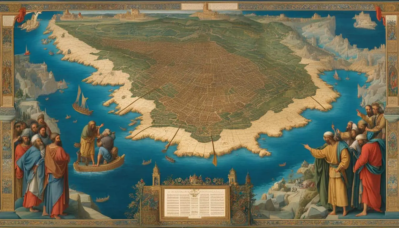
Bible Atlases and Illustrated Maps
For a more comprehensive exploration of biblical geography, Bible atlases and illustrated maps are highly recommended. Bible atlases combine maps, charts, and background information to provide a thorough understanding of the geographical aspects of the Scriptures. These resources often include detailed maps with historical annotations, timelines, and geographical features that help you visualize the ancient world. Illustrated maps, on the other hand, are particularly useful for visualizing specific routes, battles, and journeys mentioned in the Bible, offering a vivid representation of these events and their surrounding geography.
| Bible Map Resource | Features |
|---|---|
| Biblical Commentaries and Study Bibles | Explanations of biblical text, contextual maps, notes, cross-references |
| Bible Surveys and Books of Maps and Charts | Specialized maps, visual representations, comprehensive coverage |
| Bible Atlases | Maps, charts, background information, historical annotations |
| Illustrated Maps | Visual representations of specific routes, battles, and journeys |
By utilizing these diverse Bible map resources, you can enhance your biblical study and gain a deeper understanding of the geographical context in which the Scriptures were written. Whether you prefer detailed commentaries, specialized books, or comprehensive atlases, these resources offer a wealth of visual aids and contextual information to support your exploration of the landscapes, landforms, and landmarks mentioned in the Bible.

Conclusion
In conclusion, the use of Bible maps is of paramount importance in enhancing the study of the Scriptures. By incorporating these visual tools into Bible study, we can gain a deeper understanding of the geographical locations mentioned in the Bible, thus enriching our overall comprehension of the biblical narrative.
Bible maps enable us to vividly visualize the landscapes, landforms, and landmarks associated with biblical events, bringing these stories to life in a tangible way. Through these visual representations, we can immerse ourselves in the ancient world, gaining a greater appreciation for the historical and cultural context in which the biblical events unfolded.
Furthermore, Bible maps provide crucial insights into the distances between locations, the topography of the land, and the borders of ancient nations. This information allows us to better understand the movements and journeys of biblical characters, further deepening our understanding of their experiences.
Ultimately, the exploration of ancient maps and the geography of the Bible enables us to truly understand the ancient world and its significance within the biblical context. By visualizing the biblical events through the use of maps, we can engage in a more immersive and meaningful study of the Scriptures, unlocking new layers of understanding and insight.
FAQ
Why is studying ancient maps and the geography of the Bible important?
Studying ancient maps and the geography of the Bible is important because it helps us understand the historical context of biblical narratives and provides visual representations of the geographical locations mentioned in the Bible.
What do Bible maps help us visualize?
Bible maps help us visualize the landscapes, landforms, and landmarks that are integral to the stories and teachings of the Bible, bringing the biblical narrative to life.
What types of Bible map resources are available?
There are various types of Bible map resources available, including maps found in the back of Bibles, biblical commentaries, study Bibles, Bible surveys, books of maps and charts, Bible atlases, and illustrated maps.
How do maps enhance Bible study?
Maps enhance Bible study by providing valuable insights into the distances between locations, the topography of the land, and the borders of ancient nations, enabling readers to better understand the movements and journeys of biblical characters.
How do Bible maps contribute to a richer understanding of the Scriptures?
By incorporating Bible maps into our study, we can gain a deeper understanding of the geographical locations mentioned in the Bible, enhancing our overall comprehension of the biblical narrative and the ancient world in which it took place.