
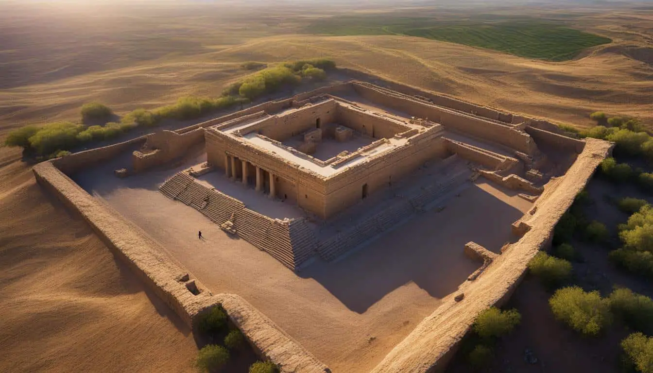
Drone surveys have revolutionized the field of biblical site exploration, providing researchers with unprecedented insights and perspectives. With the advancement of drone technology, archaeologists are now able to conduct aerial surveys of ancient ruins and sites, capturing high-resolution images and videos from above. These drone surveys offer a fresh approach to studying biblical sites, allowing researchers to uncover hidden details and gain a better understanding of the historical context. This innovative method has the potential to greatly enhance our knowledge of ancient civilizations and contribute to the field of biblical archaeology.
Key Takeaways:
- Drone surveys provide an aerial perspective for exploring biblical sites.
- High-resolution images and videos captured by drones offer valuable visual data for analysis.
- Drones are efficient and cost-effective tools for surveying large areas and inaccessible terrains.
- Successful case studies demonstrate the benefits of using drone surveys in biblical site exploration.
- Challenges such as skilled operator requirements and limited battery life should be considered.
The Benefits of Drone Surveys in Biblical Site Exploration
Using drones in biblical site exploration offers numerous benefits that provide researchers with valuable insights and enhance their understanding of these historic sites. The aerial perspective provided by drones allows for a comprehensive view of the sites from a higher vantage point, revealing patterns, structures, and features that are difficult to discern from the ground. With high-resolution cameras, drones capture detailed images and videos, providing researchers with a wealth of visual data for analysis and documentation.
This data can be used to create 3D models of the archaeological sites, enabling virtual exploration and in-depth study of the area. Researchers can examine fine details, uncover hidden artifacts, and gain a better understanding of the overall layout and historical context. This innovative approach revolutionizes the field of biblical site exploration, offering a fresh perspective that brings new dimensions to our understanding of ancient civilizations.
In addition to the aerial perspective and detailed imagery, drones offer practical advantages. They are relatively quick and cost-effective, making them efficient tools for surveying large areas and accessing previously inaccessible terrains. Drones can navigate challenging landscapes, reaching areas that may be difficult for researchers to access or dangerous to explore on foot.
By employing drone surveys, researchers can save time, reduce costs, and minimize risks associated with traditional methods of site exploration. The benefits of drone surveys in biblical site exploration are numerous, making them an indispensable tool for researchers seeking to uncover the mysteries of ancient civilizations.
Benefits of Drone Surveys in Biblical Site Exploration:
- Provides an aerial perspective for a comprehensive view of sites
- Captures high-resolution images and videos for detailed analysis
- Enables the creation of 3D models for virtual exploration
- Efficiently surveys large areas and inaccessible terrains
- Reduces costs and minimizes risks compared to traditional methods
With the benefits of drone surveys, researchers can expand their knowledge and gain unique insights into biblical sites, contributing to the advancement of biblical archaeology and our understanding of ancient civilizations.
Case Studies: Examples of Drone Surveys in Biblical Site Exploration
Several successful case studies have demonstrated the effectiveness of drone surveys in the exploration of biblical sites. These case studies highlight the valuable insights that can be gained through the use of drone technology in biblical site exploration.
Ancient City of Petra, Jordan
In the ancient city of Petra in Jordan, drone surveys have played a crucial role in mapping and documenting the intricate rock-cut architecture of the site. By capturing aerial images and videos, drones have provided researchers with an unparalleled perspective, revealing hidden structures and offering a more comprehensive understanding of the city’s layout.

Israel: Ancient Tombs and Burial Sites
In Israel, drone surveys have contributed significantly to the discovery and excavation of ancient tombs and burial sites. By conducting aerial surveys, researchers have been able to gather high-resolution visual data, shedding new light on burial practices and rituals from different time periods.
Drone surveys have allowed us to see biblical sites from a whole new perspective. The aerial view provided by drones reveals details and patterns that are often missed from ground level. This has been particularly valuable in the exploration of ancient ruins and archaeological sites, enhancing our understanding of the historical context.
These case studies demonstrate the immense potential of drone surveys in biblical site exploration. By leveraging the capabilities of drone technology, researchers can uncover hidden details, map intricate structures, and gain deeper insights into ancient civilizations.
| Case Study | Location | Key Findings |
|---|---|---|
| Ancient City of Petra | Jordan | – Mapping and documenting rock-cut architecture – Uncovering hidden structures – Comprehensive understanding of the city’s layout |
| Israel: Ancient Tombs and Burial Sites | Israel | – Discovery and excavation of ancient tombs and burial sites – Insights into burial practices and rituals from different time periods |
Challenges and Limitations of Drone Surveys in Biblical Site Exploration
While drone surveys offer numerous benefits, there are also several challenges and limitations to consider in the context of biblical site exploration. One major challenge is the need for skilled operators who possess the technical expertise to navigate the drones and capture high-quality footage. Operating a drone requires knowledge of flight regulations and the ability to handle complex flight maneuvers. This expertise is crucial to ensure the safety of the drone and the accuracy of the data collected.
Additionally, weather conditions can significantly impact the feasibility of conducting drone surveys. Strong winds, rain, or adverse weather conditions may prevent drones from flying safely, limiting the opportunities for data collection. Researchers must carefully plan their survey schedules to account for weather conditions and optimize the chances of successful survey missions.
Another limitation of drone surveys is the restricted battery life and flight time of drones. Drones typically have a limited flight range due to battery constraints, which limits the distance they can cover during a single flight. This can restrict the amount of data that can be collected in one survey and may require multiple flights to fully capture an entire biblical site. Researchers must carefully manage their resources and plan their surveys accordingly to maximize data acquisition.
Furthermore, drones are not suitable for all types of terrain and sites. Some sites may have challenging topography or complex structures that make it difficult for drones to navigate and capture accurate data. Inaccessibility due to rugged landscapes or dense vegetation can also pose challenges for drone surveys. Additionally, safety or privacy concerns may restrict the use of drones in certain areas, further limiting their applicability in biblical site exploration.
It is crucial for researchers to carefully assess the feasibility and applicability of drone surveys in each specific biblical site exploration project. Detailed planning, expertise in drone operation, and an understanding of the limitations and challenges involved are essential to ensure the successful integration of drones as a tool for data collection and analysis in the exploration of biblical sites.
Future Applications of Drone Surveys in Biblical Site Exploration
The future of drone surveys in biblical site exploration looks promising. As technology continues to advance, drones are expected to become more sophisticated and capable of carrying out complex tasks. For example, advancements in LiDAR (Light Detection and Ranging) technology may enable drones to create highly accurate 3D maps of archaeological sites, revealing even more intricate details and structures.
Furthermore, the use of artificial intelligence and machine learning algorithms can aid in the analysis and interpretation of the vast amount of data collected through drone surveys. These advancements have the potential to revolutionize the field of biblical archaeology, allowing for deeper insights and breakthrough discoveries.

By combining drone technology, LiDAR, and AI algorithms, researchers will have a powerful toolkit for uncovering hidden treasures and unraveling mysteries that have long perplexed historians and biblical scholars. The ability to create detailed 3D maps of archaeological sites will offer a new level of understanding and visual representation, allowing researchers to virtually explore and analyze the ancient ruins.
“These future applications of drone surveys will undoubtedly transform the way we approach biblical site exploration. The combination of advanced technologies will open doors to new discoveries, providing a wealth of information that was previously inaccessible.”
With these advancements, the future of drone surveys in biblical site exploration holds immense potential. Researchers will be able to gather more accurate and comprehensive data, leading to a deeper understanding of ancient civilizations and their historical context. The opportunities for groundbreaking research and new insights are boundless.
Future Applications of Drone Surveys: Potential Advancements
| Advancements | Benefits |
|---|---|
| Enhanced LiDAR Technology | Highly accurate 3D mapping of archaeological sites. |
| Artificial Intelligence and Machine Learning | Data analysis and interpretation for deeper insights. |
| Virtual Exploration | Virtual tours of ancient ruins for immersive study. |
| Automated Surveying | Faster and more efficient data collection. |
Conclusion
In conclusion, drone surveys have revolutionized the field of biblical site exploration, providing researchers with a fresh perspective and valuable data. Through aerial surveys, researchers are able to uncover hidden details, create accurate maps, and gain a deeper understanding of ancient civilizations.
While there are challenges and limitations to consider, such as the need for skilled operators and weather conditions, the future of drone surveys in biblical site exploration looks promising. With advancements in technology, drones are expected to become more sophisticated and capable of carrying out complex tasks.
As drone technology continues to evolve, it is anticipated that this innovative method will become an integral part of archaeological research, contributing to the ongoing quest for knowledge and understanding of our ancient past. Drone surveys offer an exciting and powerful tool for exploring biblical sites, further enhancing our understanding of the rich historical context and civilization.
FAQ
What is drone surveys in biblical site exploration?
Drone surveys in biblical site exploration refer to the use of unmanned aerial vehicles (UAVs), commonly known as drones, to conduct aerial surveys of ancient ruins and sites. This innovative method allows researchers to capture high-resolution images and videos from above, providing valuable insights and perspectives on biblical sites.
What are the benefits of using drone surveys in biblical site exploration?
Using drone surveys in biblical site exploration offers several key benefits. Firstly, drones provide an aerial perspective, allowing researchers to view sites from a higher vantage point and reveal patterns, structures, and features that may be difficult to discern from ground level. Additionally, drones equipped with high-resolution cameras can capture detailed images and videos, providing a wealth of visual data for analysis. Furthermore, drones are relatively quick and cost-effective, making them an efficient tool for surveying large areas and inaccessible terrains.
Can you provide examples of successful drone surveys in biblical site exploration?
Yes, there have been several successful case studies of drone surveys in the exploration of biblical sites. For example, in the ancient city of Petra in Jordan, drone surveys have helped researchers map and document the intricate rock-cut architecture of the site, revealing hidden structures and enabling a more comprehensive understanding of the city’s layout. In Israel, drone surveys have contributed to the discovery and excavation of ancient tombs and burial sites, shedding new light on burial practices and rituals of different time periods.
What are the challenges and limitations of using drone surveys in biblical site exploration?
While drone surveys offer numerous benefits, there are also several challenges and limitations to consider. One major challenge is the need for skilled operators who can navigate the drone and capture high-quality footage. Weather conditions can also pose a challenge, as strong winds or rain may prevent drones from flying safely. Additionally, drones have limited battery life and flight time, which can restrict the amount of data that can be collected in a single flight. Certain terrains and sites may also be inaccessible or off-limits for drone surveys due to safety or privacy concerns.
What are the future applications of drone surveys in biblical site exploration?
The future of drone surveys in biblical site exploration looks promising. As technology continues to advance, drones are expected to become more sophisticated and capable of carrying out complex tasks. For example, advancements in LiDAR technology may enable drones to create highly accurate 3D maps of archaeological sites, revealing even more intricate details and structures. The use of artificial intelligence and machine learning algorithms can also aid in the analysis and interpretation of the vast amount of data collected through drone surveys.
How can drone surveys contribute to the field of biblical archaeology?
Drone surveys offer researchers a new perspective and valuable data in the field of biblical archaeology. Through aerial surveys, researchers can uncover hidden details, create accurate maps, and gain a deeper understanding of ancient civilizations. This innovative method has the potential to greatly enhance our knowledge of ancient civilizations and contribute to the ongoing quest for knowledge and understanding of our ancient past.